Native American Tribes of Southwest Missouri
While some Native American tribes were in Southwest Missouri for over a thousand years, many had shorter stays. These tribes had relocated to Southwest Missouri
The Osage

The Osage were believed to be a part of the Dhegiha Sioux tribes that lived in the Ohio and Mississippi river valleys around 700 BC. During the 17th century the Iroquois invaded this region in search of hunting grounds and as a result the Osage migrated to the confluence of the Missouri and Mississippi rivers in the now St. Louis area. This group named themselves "NI-U-Ko'n-Ska which meant "Children of the Middle Waters." From here the tribe broke off into groups and moved different directions throughout Missouri, Kansas, Nebraska, Arkansas and Oklahoma.
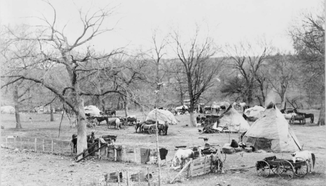
Some of the Osage people settled in what is now Greene and Christian counties. Their villages had earthen and log lodges constructed upright posts varying in length from 36-100 feet. Lodges were erected on either side on a main "street". Several times throughout the year the Osage people would go on long hunts for bear, bison and other large game. As the European market for furs increased the Osage would trade bear and beaver pelts with the Europeans for horses, guns, tobacco and cloth. During these long hunts the permanent village would be abandoned except for the elder men and women. The rest of the tribe went on the hunts and stayed in hunting camps. Along with hunting the Osage also participated in agriculture. They planted beans, squash, corn, and gathered berries and nuts.
As Anglo settlers started moving west the lands of the Osage became in high demand. Through treaties in 1808, 1818, and 1825 approximately 100,000,00 acres of Osage land was ceded to the United States Government. The total compensation of made not only in cash but livestock and merchandise represented one penny per each six acres. The Osage relocated several times throughout Missouri, Kansas and Oklahoma. In 1890 the Osage people dwindled to 2,000. However they proved successful in adapting to living in a world dominated by Anglo-Americans.
In 1872 the Osage made a final move that proved to be very wise financially. They relocated to what is now Osage County, Oklahoma. The Osage became the wealthiest tribe in North America due to the large presence of oil and gas deposits on their new lands. With the oil boom and their financial gains the Osage were now able to focus on preserving their culture. Since 1906 they have been self-governing.
The Kickapoo

As far back as the 1600s the Kickapoo (Kiikaapoi) were located along the Great Lakes in Ohio and Michigan. After the Iroquois War (1641-1701) many northern tribes, including the Kickapoo migrated west. The Kickapoo migrated first to Wisconsin and then to Illinois and Indiana. In 1819, through a treaty with the United States government, the Kickapoo were once again relocated to southern Missouri to what is now Greene County.
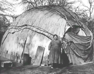
The Kickapoo built a small village in what is present day downtown Springfield, MO. The village contained approximately one hundred dwellings called wickiups. These dwellings were oblong lodges made of bent-over saplings and roofs of bark or cattail-reed mats. It is believed in its prime this village had a population of 500 people.
As the story is told, John Polk Campbell and his brother Madison, traveled to this area looking to relocate. Seeking shelter for the night the brothers set-up camp near the Kickapoo village. It was revealed that one of the young men of the tribe was ill. The brothers, having medicinal herbs with them, successfully treated the boy. In a show of gratitude some of the Kickapoo men led the Campbells to a natural well and were given use of this land. Later this would become the city of Springfield, MO.
The Kickapoo tribes were once again relocated in 1832. Having entered into at least ten treaties with the United States government between 1795-1854 the Kickapoo people were frequently relocated. Each move of the homelands proved more devastating. The Kickapoo divided into four different bands moving between Kansas, Oklahoma, Texas and Mexico. Today, there are three federally recognized tribes in Kansas, Oklahoma and Texas. In 1936, the Kickapoo Tribe of Oklahoma was organized under the Indian Welfare Act. Many of these people live in Lincoln, Oklahoma and Pottawatomie counties in Oklahoma. The Kickapoo culture and language remain strong.
The Delaware

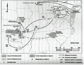
The Delaware or often referred to as Lenape were originally from the present day Delaware and Hudson River valleys. Shortly after the American Revolution the Delaware broke into at least three different groups. Some moving to Canada, some moving to the Cape Girardeau. MO area, and some in Ohio. Eventually the group that remained in Ohio were pushed further west to southwest Missouri. In 1818 as a result of the Treaty of St. Mary's a group of Delaware were moved from the west fork of the White River in Indiana to the west fork of the White River (know as the James River) in present day Christian County, MO. This land grant provided 1, 971, 200 acres of present day Christian, Stone, Barry, Lawrence and Greene counties.
The main village was set on the James fork and Wilson's Creek. The village extended up and down the river bank. Originally known as Anderson's Village, named for the Chief Anderson of the Delaware tribe, this area was also referred to as Delaware Village and later Delaware Town. Fur trade was very lucrative at this time. Two prominent fur traders, William Gillis and James Wilson (Wilson Creek namesake), also lived in this area. Their connections to the trading houses in Ste. Genevieve led to a trading post built near Anderson's Village. James Wilson traveled as an interpreter with the Delaware between Indiana and Missouri.
Archeological studies have revealed at least two sites along the James River. Through these studies it was determined the Delaware dwellings were consistent with the structural plan of a dog-trot or double-pen cabin. Typically these structures consisted of two rooms separated by a breezeway. One room would be used for cooking and the other for sleeping and living areas.
Research shows that the Delaware were not in this region for very long. Records indicating the Delaware moved here sometime in the early 1800's possibly 1806 and were forced into another treaty in 1829 relocating them to eastern Kansas. They finally purchased land in Oklahoma from the Cherokee Nation. For many years after this they were considered part of the Cherokee Nation and no longer federally recognized as Delaware. In 2009, after much dispute and negotiations, they are once again federally recognized as a tribe with around 10,000 members.
The Cherokee

The Cherokee people never lived in Southwest Missouri, but their time in Missouri is one of the most regrettable episodes in the history of the United States. The Cherokee lived in southeastern United States well before the time they encountered European explorers in 1540. By the 1830s, 125,000 Native Americans lived in Georgia, Tennessee, North Carolina, Alabama and Florida. The Anglo-Americans perceived the Native Americans as unfamiliar people who occupied lands on which they wanted to grow cotton. Their solution was to "civilize" the Native Americans, meaning having them convert to Christianity, learn to speak and read English and adapt to the European economic practices. Many Cherokee people embraced these customs.
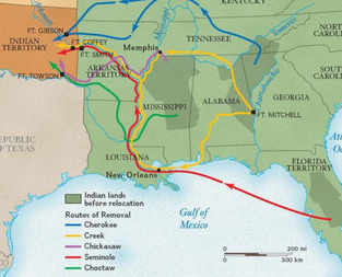
Many white settlers wanted the valuable land belonging to the Cherokee to grow cotton and later to mine gold found in Georgia. Despite assimilation, most of the Cherokee land was ceded to the United States government through numerous treaties. Continued pressure to relocate some of the Cherokee, known as Old Settlers, moved to the Indian Territory (now Oklahoma) west of the Mississippi River. In 1835 a small number of Cherokee signed a The Treaty of New Echota under President Andrew Jackson. Many Cherokee, including Chief John Ross, believed the treaty to be invalid and urged the Cherokee to remain on their land. In 1838, under the direction of President Martin Van Buren, 7000 soldiers moved in and forced Cherokee, intermarried whites and slaves to stockades. Approximately 16,000 people, where then marched 1,200 miles to the Indian Territory. This march included traveling through southwest Missouri on the southern side of present day Springfield, MO. It is estimated that 5,000 people died either in the stockades or on route due to disease, starvation, and harsh weather conditions.
Those Cherokee who survived began to rebuild their lives by joining with the Old Settlers already established in the Indian Territory. A new Cherokee constitution was ratified in 1839. By 1907, as Oklahoma became a state much of the Cherokee land as allotted. The Cherokee encountered the loss of their infrastructure including their government, courts and schools. With the loss of much of their land and support systems the Cherokee faced much poverty. In 1970, the Principal's Chief Act paved they way for the Cherokee to take back their government. Today, the Cherokee are the largest Native American group in the United States.